
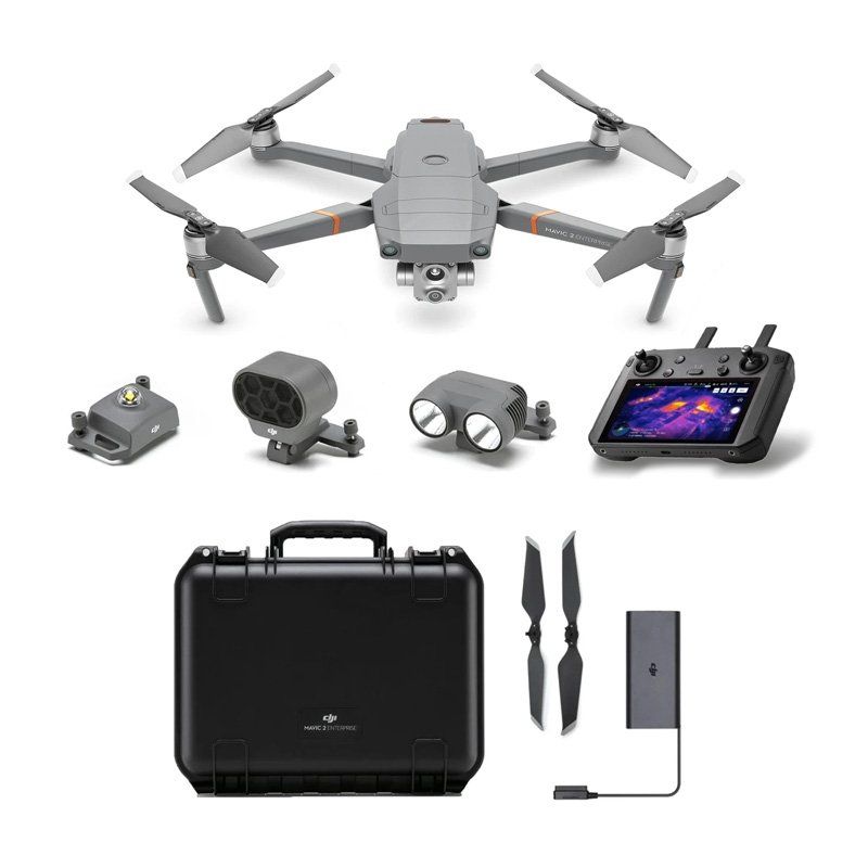
Northern Ireland's No.1 Drone Pilot Training Academy
Shipping Available
Safe Payments
Climate Change the raise of drones in Northern Ireland
Humanity faces many challenges today. Extreme events are becoming more intense and occurring more often. Energy-related carbon dioxide emissions are at an all-time high, while an increase in water pollution is destroying our ecosystems. Glaciers and ice sheets worldwide are melting, putting as many as 410 million people at risk from sea level rises.
These urgent and interconnected challenges have heightened the need for an evidence based, data-driven approach toward a green tinted recovery. In adopting the UN-approved 2030 Agenda for Sustainable Development, world leaders were in consensus that access to high-quality, timely, reliable, and disaggregated environmental data was necessary for policymaking and giving the right direction to conservation efforts.
Up until a few years ago, governments and scientific organizations at local, national, regional, and global levels were forced to rely on traditional sources of environmental data collection, namely low-resolution satellite imagery, costly aerial surveys, and time consuming and laborious ground surveys.
It didn’t help that manual data collection came with the risk of exposing workers to hazardous conditions. Meanwhile, remotely sensed satellite data offered very little flexibility in terms of acquisition features and frequency of capture, often missing out on fine-scale surface variations.
As drone technology developed, it overcame all these limitations. Drones were able to obtain data more swiftly, help respond to disasters and emergencies more effectively, and minimize the safety risks associated with work conditions.
Think about it: Would you rather send a ground team to the swampy forests of eastern Africa where the presence of crocodiles, snakes, and aggressive hippos impedes an accurate assessment of forest health, especially when you have the option to deploy drones outfitted with cutting-edge visible and infrared cameras to identify the canopy species and density from a safe distance?
With their unrivalled safety record, DJI drones are capable of carrying a multitude of sensors, high-resolution cameras, and survey-grade mapping payloads. These solutions facilitate frequent and consistent environmental monitoring, conservation, and green energy efforts. In addition, our drones are cost effective, which makes climate monitoring and reporting viable even for those agencies that must work within limited budgets.
Today, DJI drones are being used globally to support scientific research that strives to understand the changing climate and the world around us.
As the case studies that follow would illustrate, our drones are helping protect fragile ecosystems from rising sea levels, natural disasters, and deforestation. DJI drones are monitoring and helping to protect threatened species. In addition, we are supporting and maintaining new green infrastructure, while helping existing infrastructure become greener and avoid industrial disasters. We are joined in our quest to benefit society by countless third-party developers and innovators who are leveraging DJI platforms to develop ingenious methods that target particular conservation actions, such as fighting wildfires, monitoring whale health, planting seeds from the sky to repopulate forest land, and collecting air samples in the Amazon rainforest.


Contact Us


OPENING HOURS
- Mon - Thu
- -
- Fri - Sat
- -
- Sunday
- Closed
Special Opening Hours available on request
Contact
Robert Dobbin
All Rights Reserved © 2025 | Dronepilotdeploy.com | Online Exam Procedures | Website built by Infoserve | Privacy Policy | Terms & Conditions | Sitemap |